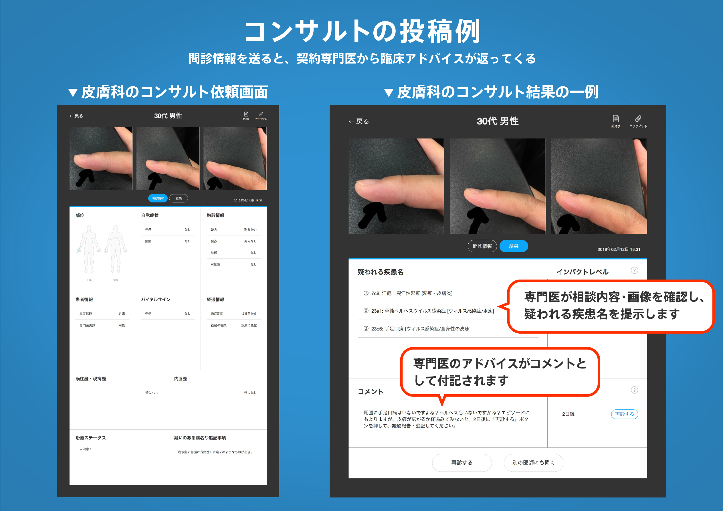
著名医師による解説が無料で読めます
すると翻訳の精度が向上します
背景:近所の公園をより多く持っていることは、子供の全体的な身体活動の増加に関連している可能性がありますが、子供が実際に身体活動に公園を使用する程度に関する情報は不足しています。 目的:この研究では、アクセルメーター、GPS、GIS、および自己報告方法を組み合わせて、子供の身体活動の近隣公園の利用可能性、近接性、および使用を調べました。 方法:南カリフォルニアの郊外のコミュニティの低〜中所得の子供(8〜14歳)(n = 135)は、それぞれ7日間にわたってアクティグラフ加速度計とGlobalSat BT-335 GPSデバイスを着用して、それぞれ身体活動と公園の使用を測定しました。Arcgisは、子供の家の500 mの住宅バッファー内の公園を特定しました。両親は、近隣の環境ウォーク可能性調査(ニュース)を通じて、近所の公園の近接性に対する認識を報告しました。データは2009年3月から2010年12月まで収集され、2013年に分析されました。 結果:家族の54%が公園から500 m以内に住んでいました。これらの子供のうち、GPSデータは16%が15分以上使用し、7日間の研究期間中に5分から15分間の子供の11%が使用したことを示しました。延長された公園の使用(15分以上)の確率は、家と最寄りの近所の公園の間の距離が100 m減少すると、4倍に増加しました。さらに、公園の使用(> 5分)の確率は、パークグリーンネス/植生密度の25パーセンタイルから75パーセンタイルに移動すると2倍になりました。 結論:子供の近所の公園の使用は一般的に低かったが、公園が子供の家に近く、植生密度が高いと、大幅に増加した。
背景:近所の公園をより多く持っていることは、子供の全体的な身体活動の増加に関連している可能性がありますが、子供が実際に身体活動に公園を使用する程度に関する情報は不足しています。 目的:この研究では、アクセルメーター、GPS、GIS、および自己報告方法を組み合わせて、子供の身体活動の近隣公園の利用可能性、近接性、および使用を調べました。 方法:南カリフォルニアの郊外のコミュニティの低〜中所得の子供(8〜14歳)(n = 135)は、それぞれ7日間にわたってアクティグラフ加速度計とGlobalSat BT-335 GPSデバイスを着用して、それぞれ身体活動と公園の使用を測定しました。Arcgisは、子供の家の500 mの住宅バッファー内の公園を特定しました。両親は、近隣の環境ウォーク可能性調査(ニュース)を通じて、近所の公園の近接性に対する認識を報告しました。データは2009年3月から2010年12月まで収集され、2013年に分析されました。 結果:家族の54%が公園から500 m以内に住んでいました。これらの子供のうち、GPSデータは16%が15分以上使用し、7日間の研究期間中に5分から15分間の子供の11%が使用したことを示しました。延長された公園の使用(15分以上)の確率は、家と最寄りの近所の公園の間の距離が100 m減少すると、4倍に増加しました。さらに、公園の使用(> 5分)の確率は、パークグリーンネス/植生密度の25パーセンタイルから75パーセンタイルに移動すると2倍になりました。 結論:子供の近所の公園の使用は一般的に低かったが、公園が子供の家に近く、植生密度が高いと、大幅に増加した。
BACKGROUND: Although having a greater number of neighborhood parks may be associated with greater overall physical activity in children, information is lacking about the extent to which children actually use parks for physical activity. PURPOSE: This study combined accelerometer, GPS, GIS, and self-report methods to examine neighborhood park availability, perceived proximity, and use for physical activity in children. METHODS: Low- to middle-income children (aged 8-14 years) (n=135) from suburban communities in Southern California wore an Actigraph accelerometer and GlobalSat BT-335 GPS device across 7 days to measure physical activity and park use, respectively. ArcGIS identified parks within a 500-m residential buffer of children's homes. Parents reported perceptions of neighborhood park proximity through the Neighborhood Environment Walkability Survey (NEWS). Data were collected from March 2009 to December 2010, and analyzed in 2013. RESULTS: Fifty-four percent of families lived within 500 m of a park. Of these children, GPS data indicated that 16% used it more than 15 minutes and an additional 11% of children used it between 5 and 15 minutes during the 7-day study period. The odds of extended park use (>15 minutes) increased fourfold when the distance between home and the nearest neighborhood park decreased by 100 m. Additionally, the odds of any park use (>5 minutes) doubled when moving from the 25th to the 75th percentile for park greenness/vegetation density. CONCLUSIONS: Although children's use of neighborhood parks was generally low, it increased substantially when parks were closer to children's homes and had greater vegetation density.
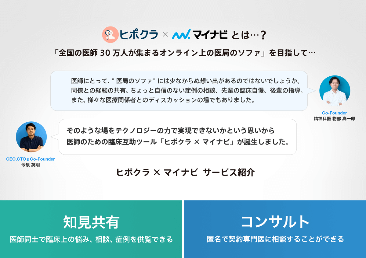
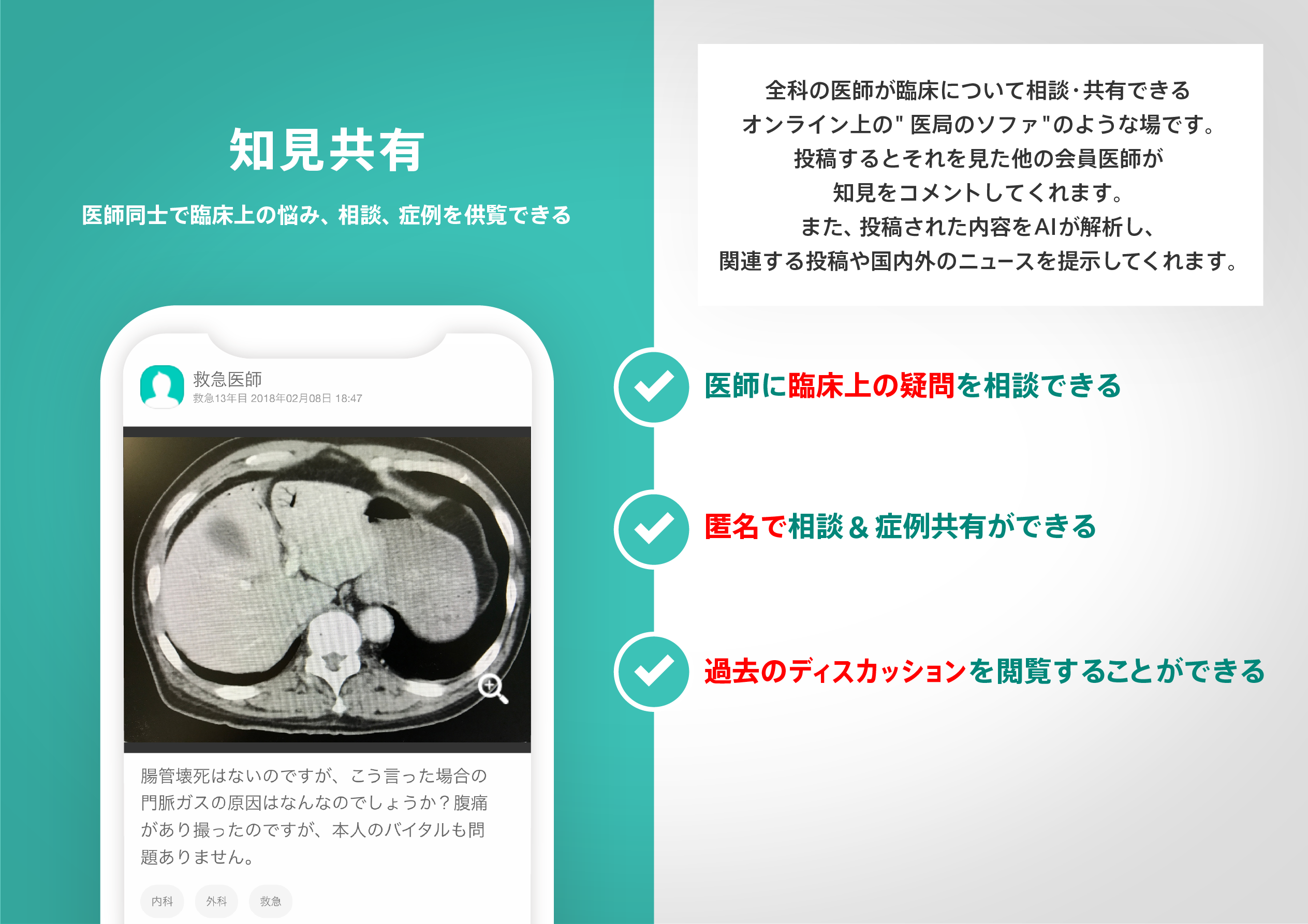
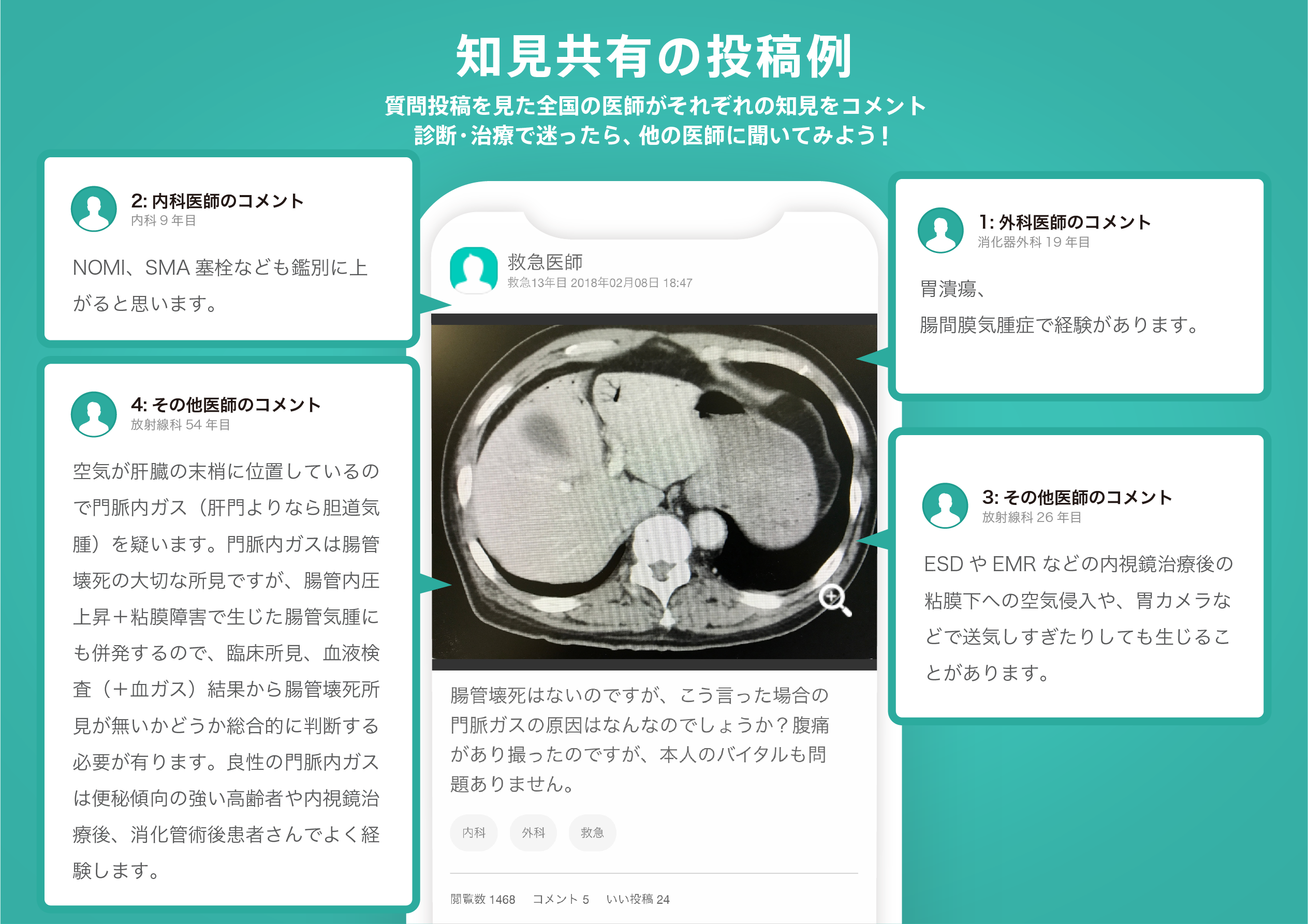
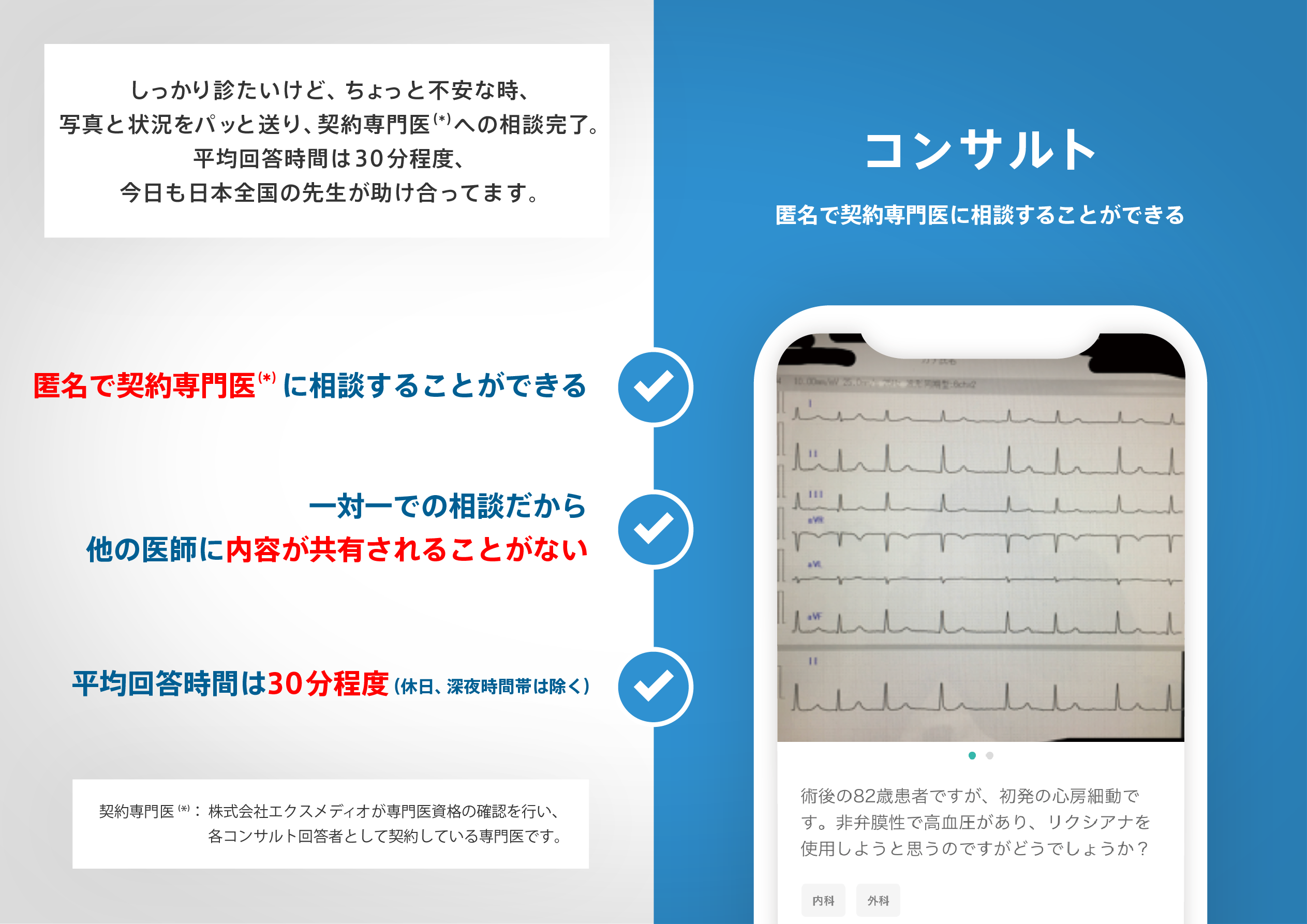
医師のための臨床サポートサービス
ヒポクラ x マイナビのご紹介

無料会員登録していただくと、さらに便利で効率的な検索が可能になります。