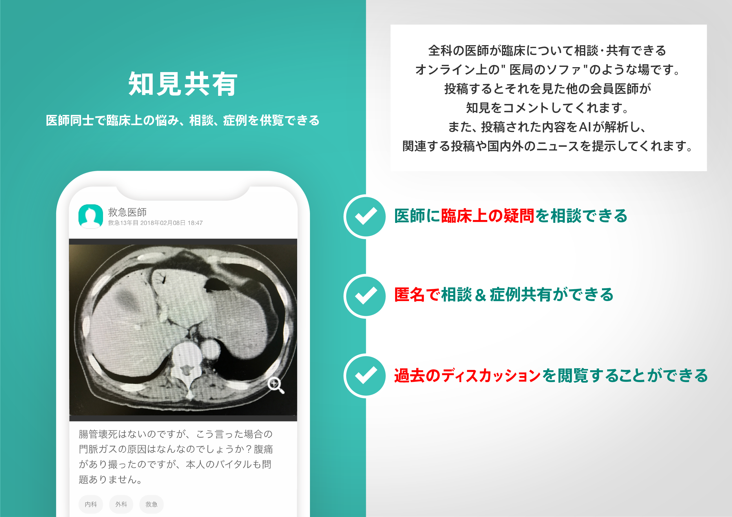
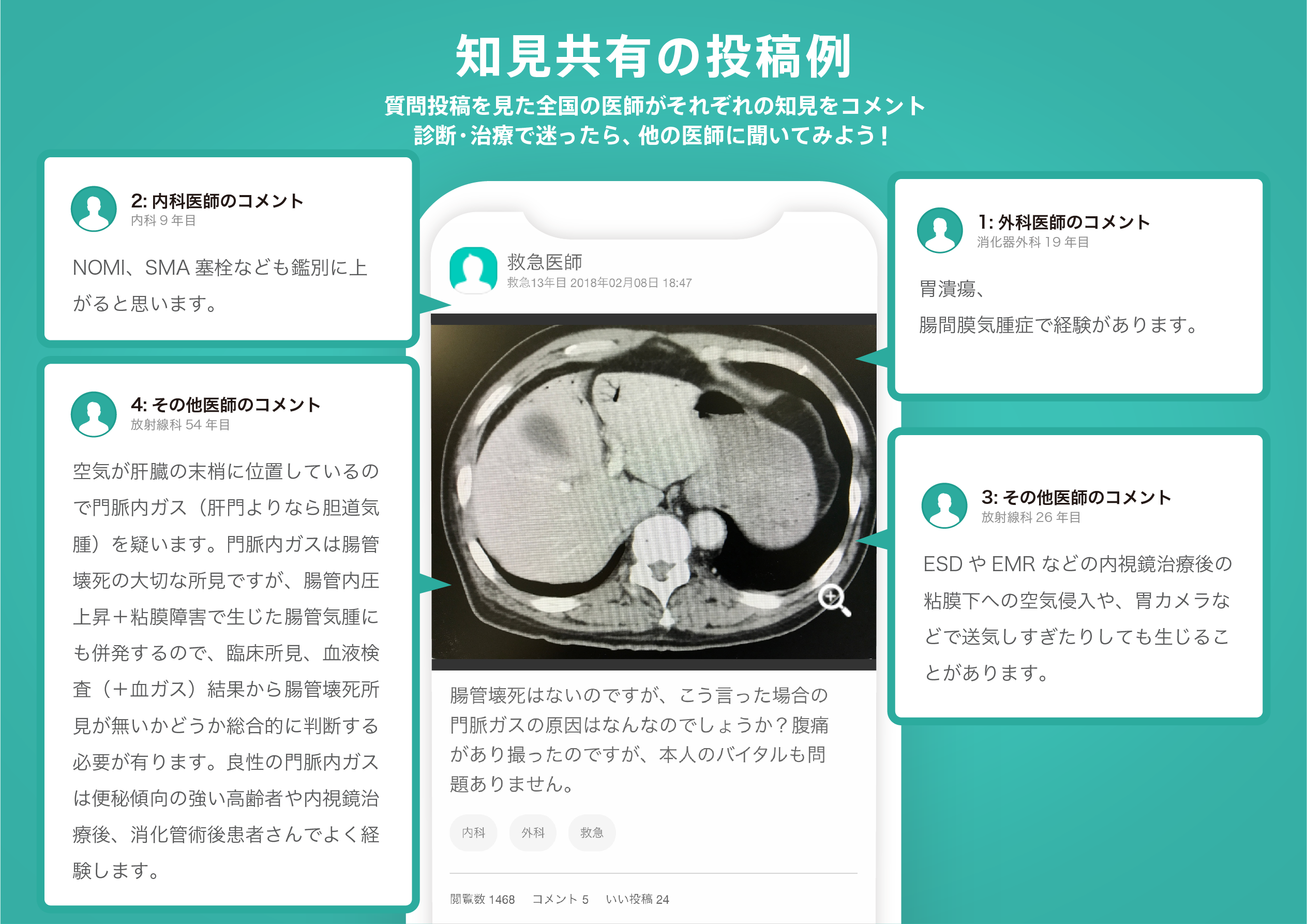
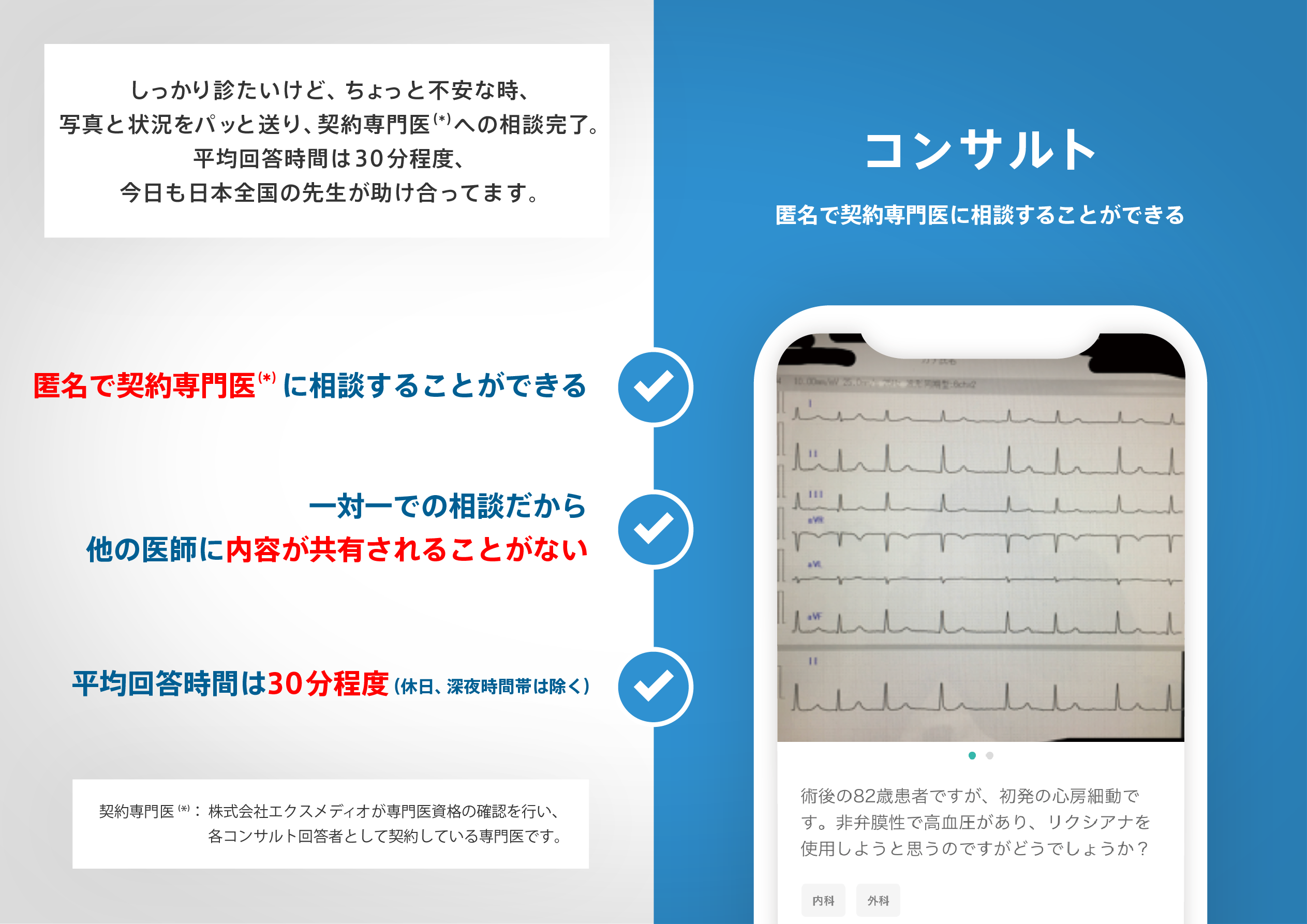
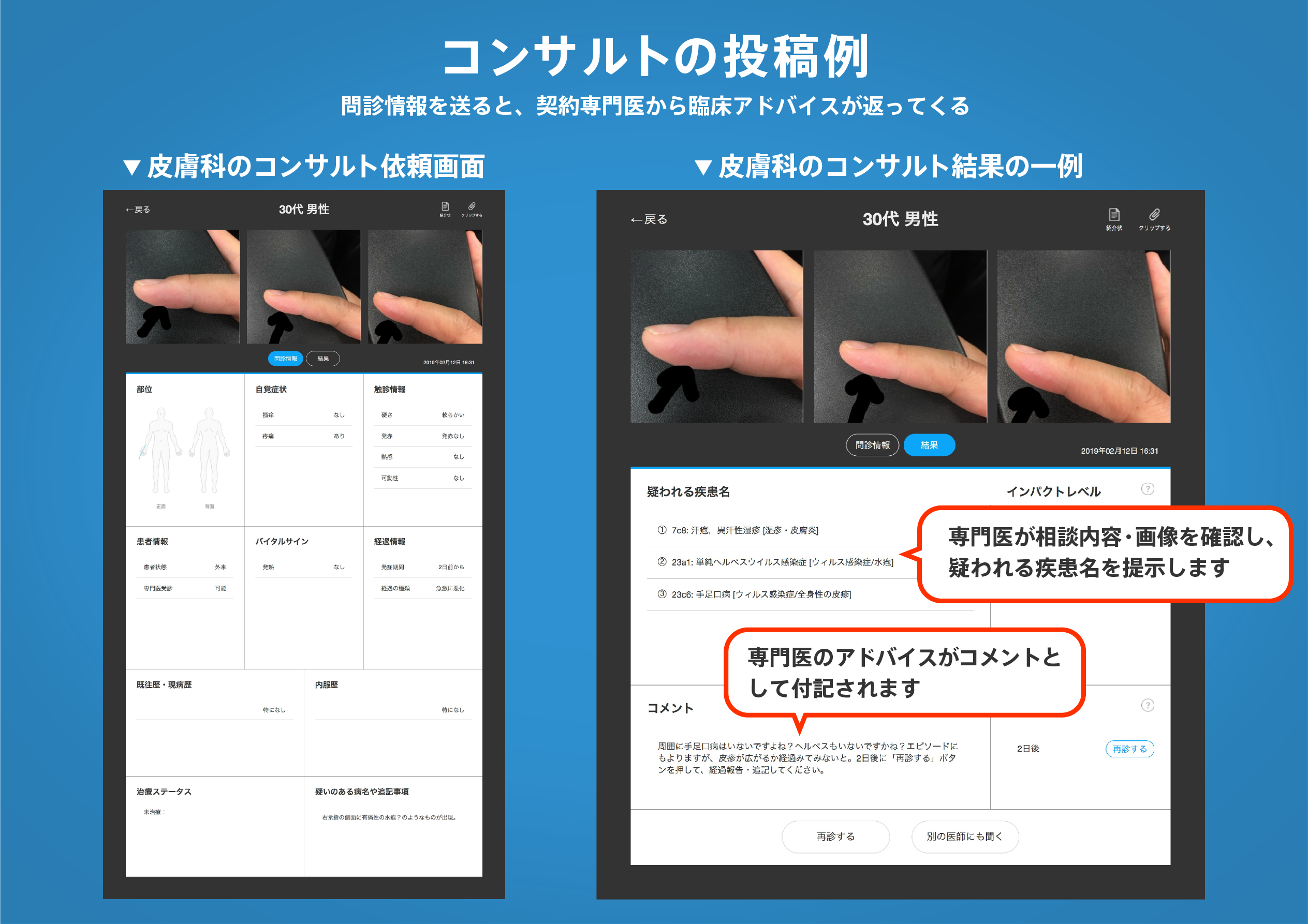
著名医師による解説が無料で読めます
すると翻訳の精度が向上します
背景:サービスへの移動時間のモデリングは、サービスの提供を計画するための一般的な公衆衛生ツールになりましたが、これらの分析の有用性は、正確な入力データの可用性と仮定とパラメーター化に固有の制限によって制約されます。これは、基本的なデータへのアクセスが制限され、旅行が複雑でマルチモーダルであることが多い発展途上国で特に問題です。このコンテキストでの精度と関連性を改善するには、地元の知識の組み込みと複数の旅行シナリオの迅速な調査を容易にするためのツールへのアクセスと柔軟性の向上と柔軟性が必要です。この作業の目的は、シンプルなオープンソース、適応可能なインタラクティブな移動時間モデリングツールを開発して、サービスアクセス分析へのアクセスと参加を可能にすることでした。 結果:記載されているのは、サービスアクセスのGIS分析のより広範な使用に対する障壁の一部を減らし、サービスの可用性の複雑な空間的および時間的変動を可能にするように設計された3つの相互接続されたアプリケーションです。これらのアプリケーションは、オープンソースのGISツールキットと2つの地理シミュレーションモデルです。これらのツールの開発は、発展途上国の文脈からの医療サービスの問題に導かれましたが、健康アクセスモデリングへのアクセスと柔軟性を高めるための一般的なアプローチを提示します。このツールは、旅行時間評価を実施するプロセスを大幅に簡素化し、オープンソースGIS形式で動的でインタラクティブなアプローチを実証する方法を実証します。さらに、このペーパーでは、これらのツールがより良い政策と計画を通知した経験的経験の例を提供します。 結論:旅行と医療サービスへのアクセスは複雑であり、いくつかの静的モデル化された出力に減らすことはできません。このペーパーで説明されているアプローチは、この複雑さを探求し、議論を促進し、より良い計画結果を生み出すことを目標に理解を築くために、一意のツールセットを使用しています。説明されているアプリケーションのアクセス可能で柔軟でインタラクティブで応答性の高い性質は、複雑な環境の社会的および政治的考慮事項を組み込んで視覚化できる可能性があります。証拠に基づいた計画をサポートすることにより、説明されている革新的なモデリングの実践は、発展途上国の地元の健康と緊急対応計画を支援する可能性があります。
背景:サービスへの移動時間のモデリングは、サービスの提供を計画するための一般的な公衆衛生ツールになりましたが、これらの分析の有用性は、正確な入力データの可用性と仮定とパラメーター化に固有の制限によって制約されます。これは、基本的なデータへのアクセスが制限され、旅行が複雑でマルチモーダルであることが多い発展途上国で特に問題です。このコンテキストでの精度と関連性を改善するには、地元の知識の組み込みと複数の旅行シナリオの迅速な調査を容易にするためのツールへのアクセスと柔軟性の向上と柔軟性が必要です。この作業の目的は、シンプルなオープンソース、適応可能なインタラクティブな移動時間モデリングツールを開発して、サービスアクセス分析へのアクセスと参加を可能にすることでした。 結果:記載されているのは、サービスアクセスのGIS分析のより広範な使用に対する障壁の一部を減らし、サービスの可用性の複雑な空間的および時間的変動を可能にするように設計された3つの相互接続されたアプリケーションです。これらのアプリケーションは、オープンソースのGISツールキットと2つの地理シミュレーションモデルです。これらのツールの開発は、発展途上国の文脈からの医療サービスの問題に導かれましたが、健康アクセスモデリングへのアクセスと柔軟性を高めるための一般的なアプローチを提示します。このツールは、旅行時間評価を実施するプロセスを大幅に簡素化し、オープンソースGIS形式で動的でインタラクティブなアプローチを実証する方法を実証します。さらに、このペーパーでは、これらのツールがより良い政策と計画を通知した経験的経験の例を提供します。 結論:旅行と医療サービスへのアクセスは複雑であり、いくつかの静的モデル化された出力に減らすことはできません。このペーパーで説明されているアプローチは、この複雑さを探求し、議論を促進し、より良い計画結果を生み出すことを目標に理解を築くために、一意のツールセットを使用しています。説明されているアプリケーションのアクセス可能で柔軟でインタラクティブで応答性の高い性質は、複雑な環境の社会的および政治的考慮事項を組み込んで視覚化できる可能性があります。証拠に基づいた計画をサポートすることにより、説明されている革新的なモデリングの実践は、発展途上国の地元の健康と緊急対応計画を支援する可能性があります。
BACKGROUND: Modelling travel time to services has become a common public health tool for planning service provision but the usefulness of these analyses is constrained by the availability of accurate input data and limitations inherent in the assumptions and parameterisation. This is particularly an issue in the developing world where access to basic data is limited and travel is often complex and multi-modal. Improving the accuracy and relevance in this context requires greater accessibility to, and flexibility in, travel time modelling tools to facilitate the incorporation of local knowledge and the rapid exploration of multiple travel scenarios. The aim of this work was to develop simple open source, adaptable, interactive travel time modelling tools to allow greater access to and participation in service access analysis. RESULTS: Described are three interconnected applications designed to reduce some of the barriers to the more wide-spread use of GIS analysis of service access and allow for complex spatial and temporal variations in service availability. These applications are an open source GIS tool-kit and two geo-simulation models. The development of these tools was guided by health service issues from a developing world context but they present a general approach to enabling greater access to and flexibility in health access modelling. The tools demonstrate a method that substantially simplifies the process for conducting travel time assessments and demonstrate a dynamic, interactive approach in an open source GIS format. In addition this paper provides examples from empirical experience where these tools have informed better policy and planning. CONCLUSION: Travel and health service access is complex and cannot be reduced to a few static modeled outputs. The approaches described in this paper use a unique set of tools to explore this complexity, promote discussion and build understanding with the goal of producing better planning outcomes. The accessible, flexible, interactive and responsive nature of the applications described has the potential to allow complex environmental social and political considerations to be incorporated and visualised. Through supporting evidence-based planning the innovative modelling practices described have the potential to help local health and emergency response planning in the developing world.
医師のための臨床サポートサービス
ヒポクラ x マイナビのご紹介


無料会員登録していただくと、さらに便利で効率的な検索が可能になります。