著名医師による解説が無料で読めます
すると翻訳の精度が向上します
カメラの画像とビデオ録画は、自然の生息地で動物を調査するためのシンプルで非侵襲的なツールです。ただし、定量的評価では、多くの場合、画像のオブジェクト位置、サイズ、距離の正確な再構成が必要です。ここでは、このような計算を実行するためのオープンソースソフトウェアパッケージを提供します。私たちのアプローチにより、ユーザーは視点の歪みを修正したり、画像を「鳥瞰の」ビューの投影に変換したり、画像座標を現実世界の座標に変換したり、その逆を可能にしたりできます。このような画像補正と変換(標高、傾斜/ロール角、およびカメラの見出し)を実行するために必要な外因性カメラパラメーターは、可視水平、ランドマークのGPS座標、既知のオブジェクトサイズ、または異なる視聴角から得られた同じオブジェクトの画像などのコンテキスト情報を使用して画像から取得されます。すべての数学操作は、PythonパッケージCameratransformに実装されています。実装のパフォーマンスは、既知のカメラパラメーターを備えたコンピューター生成された合成画像を使用して評価されます。さらに、皇帝ペンギンコロニーの画像でアルゴリズムをテストし、カメラの傾きとロールアングルを1度未満の誤差で推定できることを示し、カメラの標高は5%未満であることを示しています。Cameratransformソフトウェアパッケージは、カメラマトリックスベースの画像変換と定量的画像情報の抽出を簡素化します。生態学的コンテキストでの広範なドキュメントと使用例は、http://cameratransform.readthedocs.ioで提供されています。
カメラの画像とビデオ録画は、自然の生息地で動物を調査するためのシンプルで非侵襲的なツールです。ただし、定量的評価では、多くの場合、画像のオブジェクト位置、サイズ、距離の正確な再構成が必要です。ここでは、このような計算を実行するためのオープンソースソフトウェアパッケージを提供します。私たちのアプローチにより、ユーザーは視点の歪みを修正したり、画像を「鳥瞰の」ビューの投影に変換したり、画像座標を現実世界の座標に変換したり、その逆を可能にしたりできます。このような画像補正と変換(標高、傾斜/ロール角、およびカメラの見出し)を実行するために必要な外因性カメラパラメーターは、可視水平、ランドマークのGPS座標、既知のオブジェクトサイズ、または異なる視聴角から得られた同じオブジェクトの画像などのコンテキスト情報を使用して画像から取得されます。すべての数学操作は、PythonパッケージCameratransformに実装されています。実装のパフォーマンスは、既知のカメラパラメーターを備えたコンピューター生成された合成画像を使用して評価されます。さらに、皇帝ペンギンコロニーの画像でアルゴリズムをテストし、カメラの傾きとロールアングルを1度未満の誤差で推定できることを示し、カメラの標高は5%未満であることを示しています。Cameratransformソフトウェアパッケージは、カメラマトリックスベースの画像変換と定量的画像情報の抽出を簡素化します。生態学的コンテキストでの広範なドキュメントと使用例は、http://cameratransform.readthedocs.ioで提供されています。
Camera images and video recordings are simple and non-invasive tools to investigate animals in their natural habitat. Quantitative evaluations, however, often require an exact reconstruction of object positions, sizes, and distances in the image. Here, we provide an open source software package to perform such calculations. Our approach allows the user to correct for perspective distortion, transform images to "bird's-eye" view projections, or transform image-coordinates to real-world coordinates and vice versa. The extrinsic camera parameters that are necessary to perform such image corrections and transformations (elevation, tilt/roll angle, and heading of the camera) are obtained from the image using contextual information such as a visible horizon, GPS coordinates of landmarks, known object sizes, or images of the same object obtained from different viewing angles. All mathematical operations are implemented in the Python package CameraTransform. The performance of the implementation is evaluated using computer-generated synthetic images with known camera parameters. Moreover, we test our algorithm on images of emperor penguin colonies, and demonstrate that the camera tilt and roll angles can be estimated with an error of less than one degree, and the camera elevation with an error of less than 5%. The CameraTransform software package simplifies camera matrix-based image transformations and the extraction of quantitative image information. An extensive documentation and usage examples in an ecological context are provided at http://cameratransform.readthedocs.io.
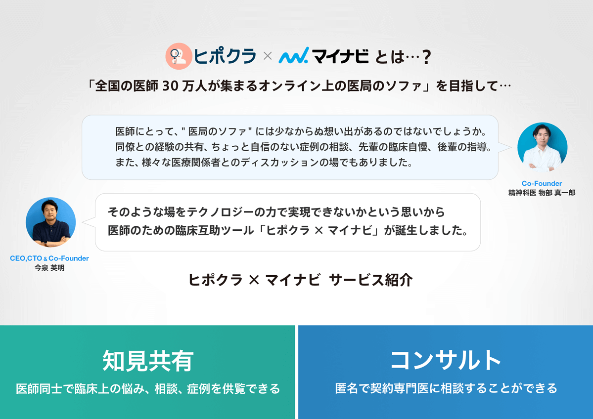
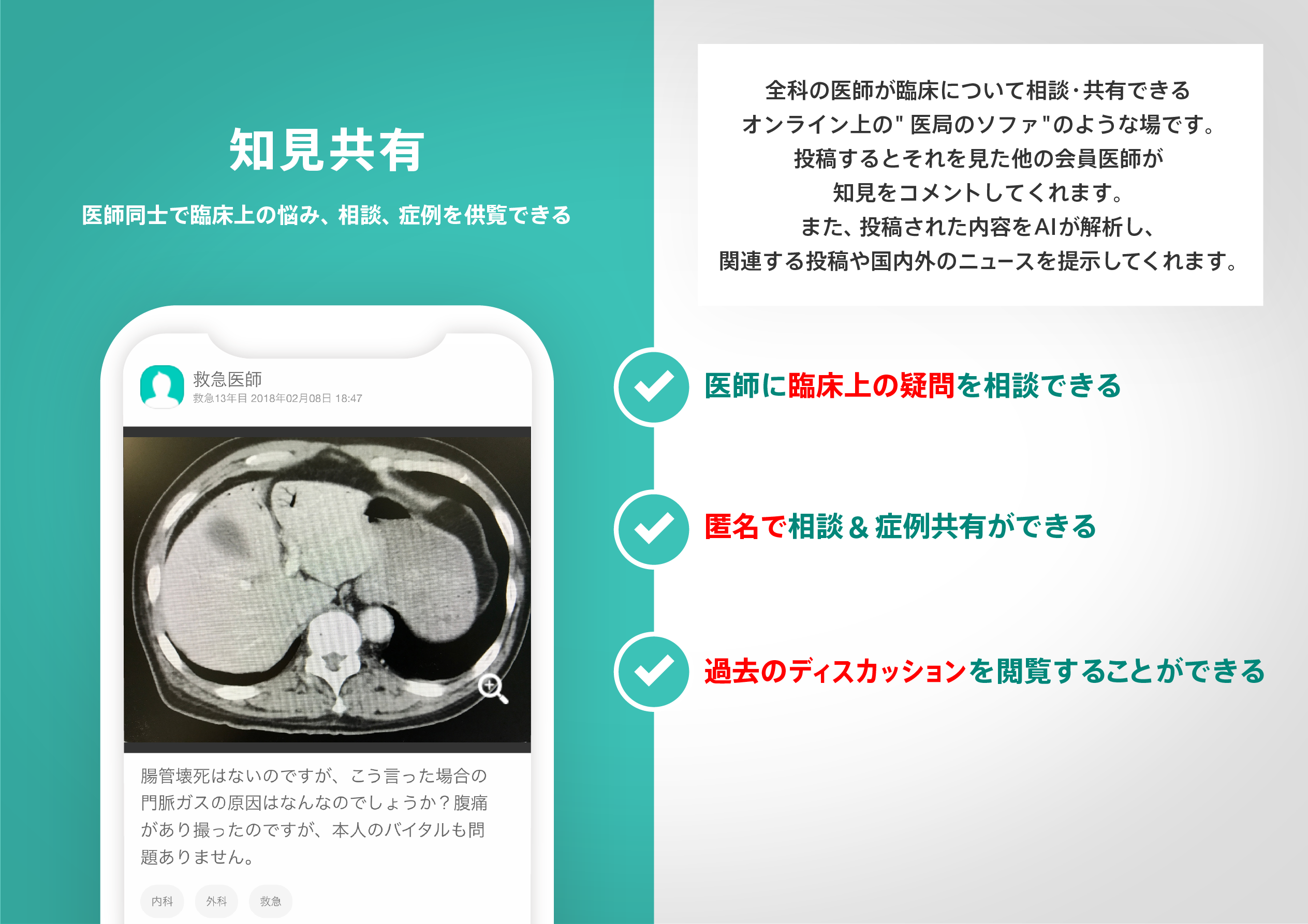
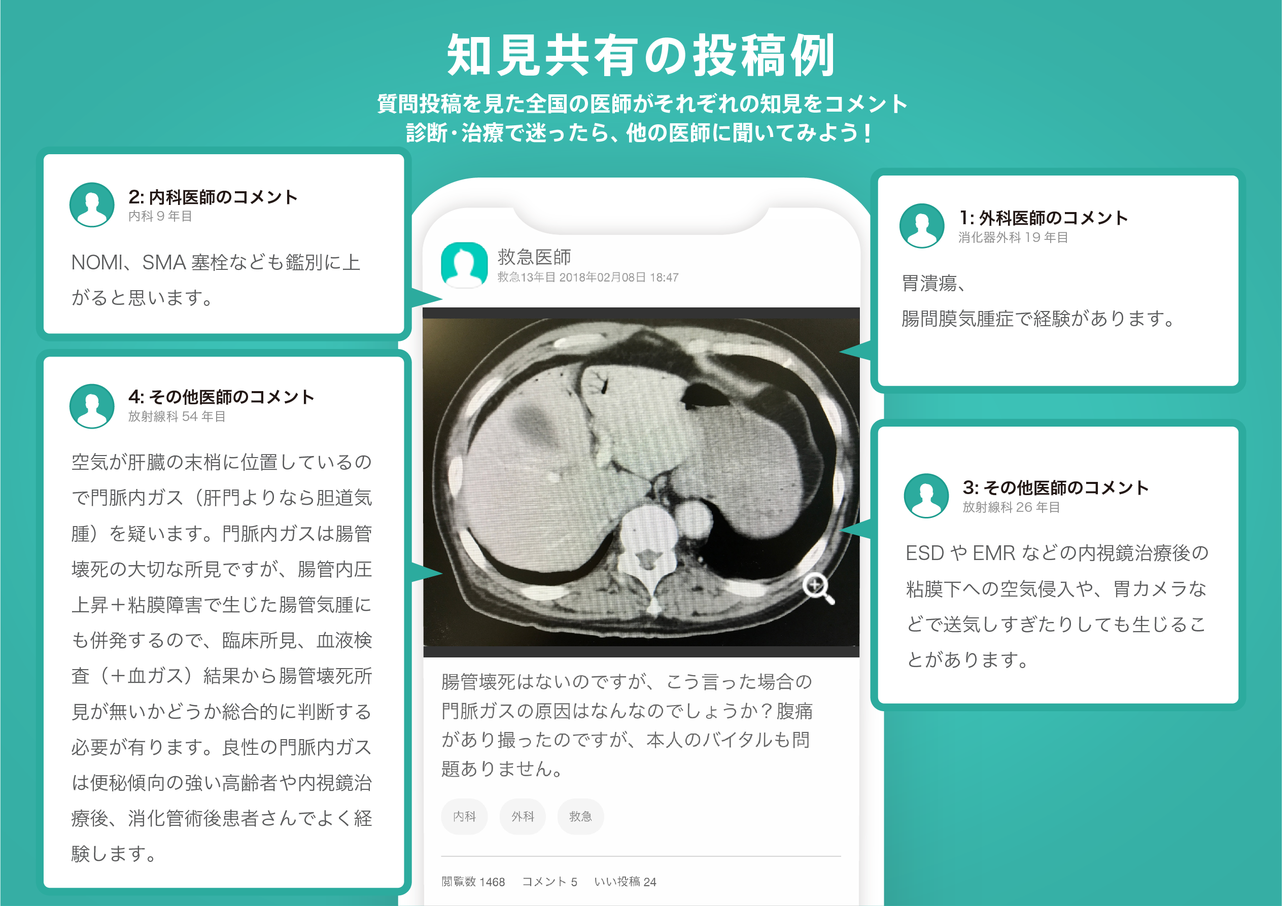
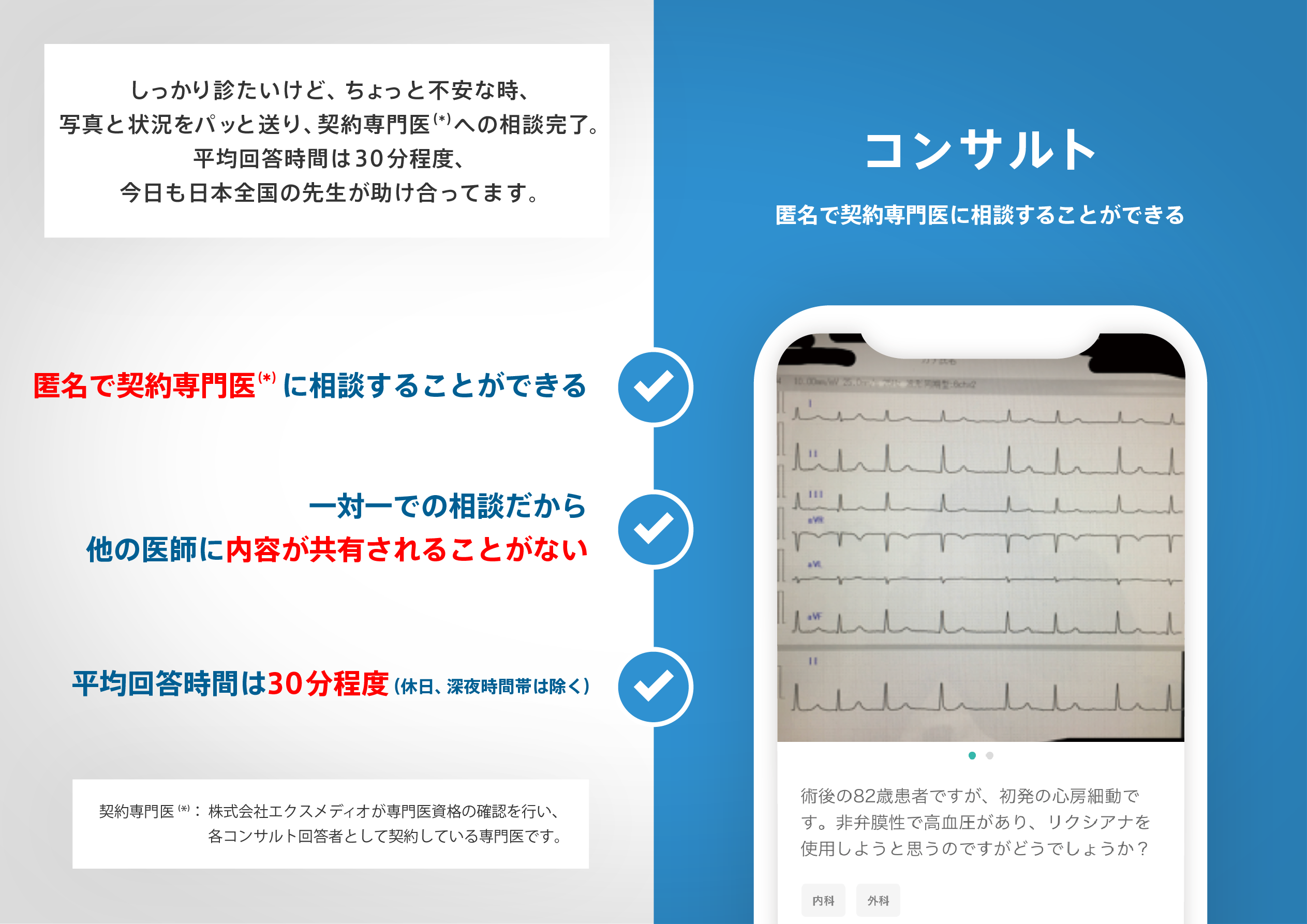
医師のための臨床サポートサービス
ヒポクラ x マイナビのご紹介

無料会員登録していただくと、さらに便利で効率的な検索が可能になります。