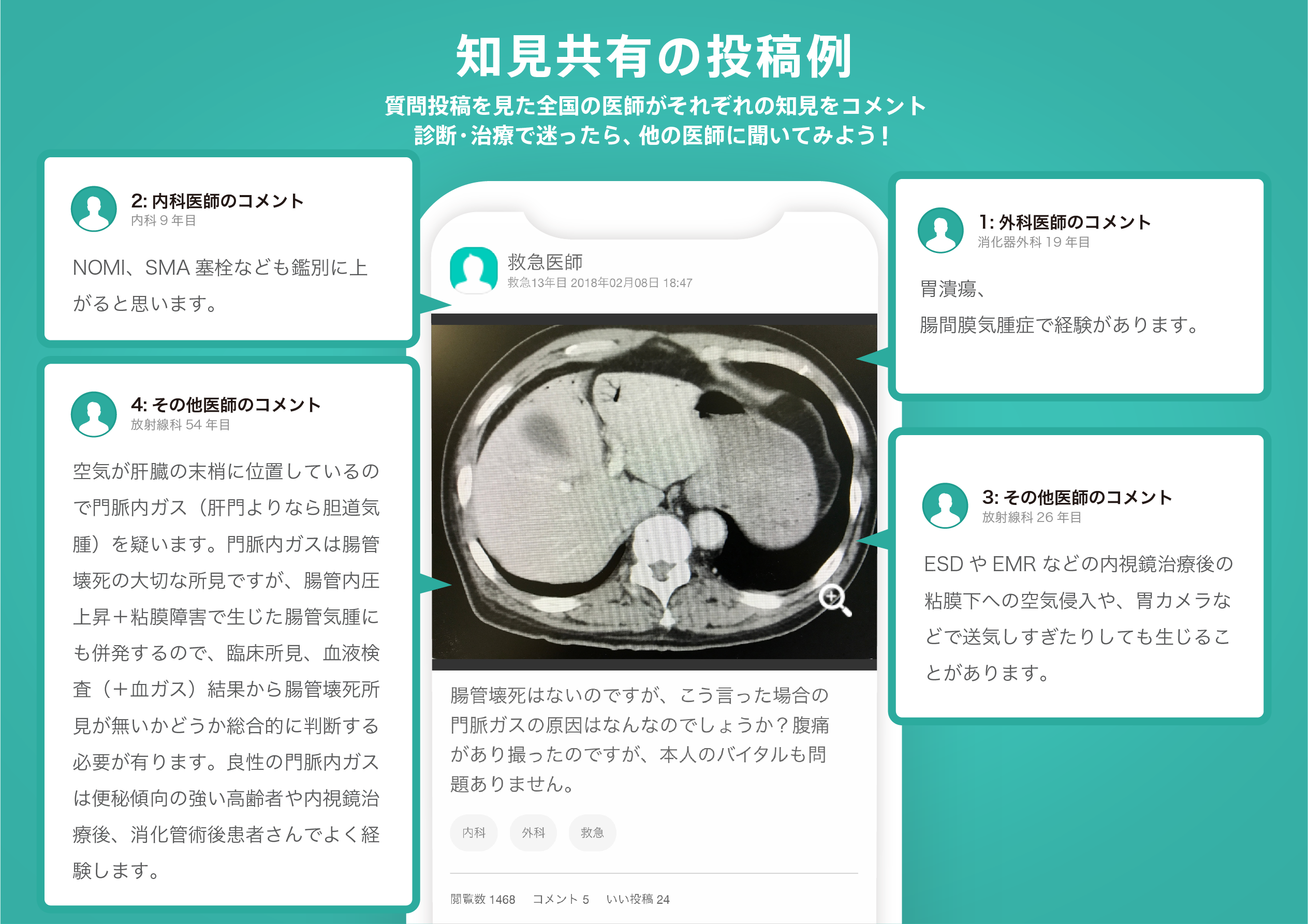
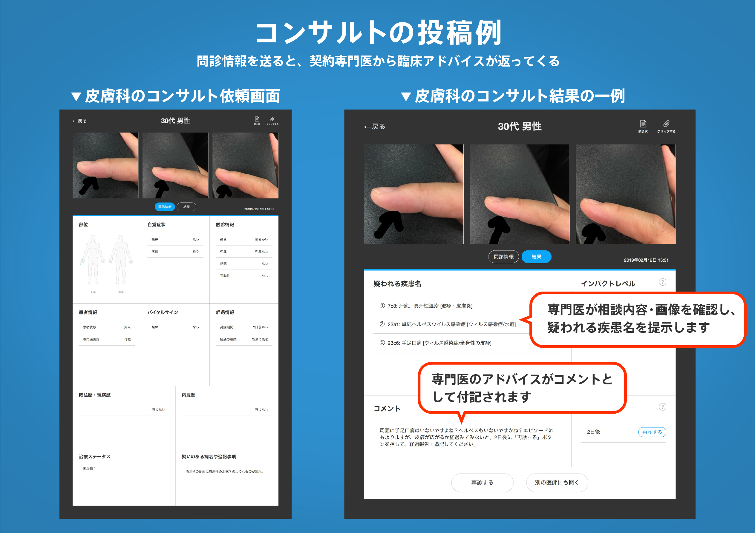
著名医師による解説が無料で読めます
すると翻訳の精度が向上します
人口の増加と関連する生態学的空間職業は、地域の生態学的安全と社会的安定性に大きなリスクをもたらしています。中国では、都市化と産業建設を禁止した「生態学的保全レッドライン」(ECR)が、空間的不一致と管理矛盾を解決するための国家政策として提案されています。しかし、非友好的な人間の妨害活動(例:栽培、鉱業、インフラストラクチャの建設など)は依然としてECR内に存在し、生態学的安定と安全性に対する大きな脅威をもたらします。この記事では、ベイジアンネットワーク(BN)-GIS確率モデルが、地域規模でECRに対する人間の妨害リスクに空間的かつ定量的に対処するために提案されています。ベイジアンモデルは、複数の人間の活動、ECRの生態学的受容体、および人間の妨害リスクを計算するための暴露関係を統合します。次に、ケース学習方法地理情報システム(GIS)を導入して、変数の空間属性に基づいてBNモデルを訓練して、リスクの空間分布と相関を評価します。このアプローチは、2018年に中国の江蘇省で描かれたECRの人間の妨害リスク評価に適用されました。結果は、ECRのほとんどが低または中程度の人間の妨害リスクレベルであることを示していますが、リアニョンガン市のいくつかの飲料水源と森林公園が最高のリスクを持っていることが示されました。感度分析の結果は、特に農地に対するECRの脆弱性を示し、それが人間の妨害リスクに最も貢献しました。この空間的に確率的な方法は、モデルの予測精度を高めるだけでなく、意思決定者が政策設計と保存介入の優先順位を確立する方法を決定するのにも役立ちます。全体として、それは後のECR調整と、地域規模での人間の妨害リスクの監督と管理の基盤を提示します。
人口の増加と関連する生態学的空間職業は、地域の生態学的安全と社会的安定性に大きなリスクをもたらしています。中国では、都市化と産業建設を禁止した「生態学的保全レッドライン」(ECR)が、空間的不一致と管理矛盾を解決するための国家政策として提案されています。しかし、非友好的な人間の妨害活動(例:栽培、鉱業、インフラストラクチャの建設など)は依然としてECR内に存在し、生態学的安定と安全性に対する大きな脅威をもたらします。この記事では、ベイジアンネットワーク(BN)-GIS確率モデルが、地域規模でECRに対する人間の妨害リスクに空間的かつ定量的に対処するために提案されています。ベイジアンモデルは、複数の人間の活動、ECRの生態学的受容体、および人間の妨害リスクを計算するための暴露関係を統合します。次に、ケース学習方法地理情報システム(GIS)を導入して、変数の空間属性に基づいてBNモデルを訓練して、リスクの空間分布と相関を評価します。このアプローチは、2018年に中国の江蘇省で描かれたECRの人間の妨害リスク評価に適用されました。結果は、ECRのほとんどが低または中程度の人間の妨害リスクレベルであることを示していますが、リアニョンガン市のいくつかの飲料水源と森林公園が最高のリスクを持っていることが示されました。感度分析の結果は、特に農地に対するECRの脆弱性を示し、それが人間の妨害リスクに最も貢献しました。この空間的に確率的な方法は、モデルの予測精度を高めるだけでなく、意思決定者が政策設計と保存介入の優先順位を確立する方法を決定するのにも役立ちます。全体として、それは後のECR調整と、地域規模での人間の妨害リスクの監督と管理の基盤を提示します。
Population growth and associated ecological space occupation are posing great risks to regional ecological security and social stability. In China, "Ecological Conservation Redline" (ECR) that prohibited urbanization and industrial construction has been proposed as a national policy to resolve spatial mismatches and management contradictions. However, unfriendly human disturbance activities (e.g., cultivation, mining, and infrastructure construction) still exist within the ECR, posing a great threat to ecological stability and safety. In this article, a Bayesian network (BN)-GIS probabilistic model is proposed to spatially and quantitatively address the human disturbance risk to the ECR at the regional scale. The Bayesian models integrate multiple human activities, ecological receptors of the ECR, and their exposure relationships for calculating the human disturbance risk. The case learning method geographic information systems (GIS) is then introduced to train BN models based on the spatial attribute of variables to evaluate the spatial distribution and correlation of risks. This approach was applied to the human disturbance risk assessment for the ECR that was delineated in 2018 in Jiangsu Province, China. The results indicated that most of the ECRs were at a low or medium human disturbance risk level, while some drinking water sources and forest parks in Lianyungang City possessed the highest risk. The sensitivity analysis result showed the ECR vulnerability, especially for cropland, that contributed most to the human disturbance risk. This spatially probabilistic method can not only enhance model's prediction precision, but also help decision-makers to determine how to establish priorities for policy design and conservation interventions. Overall, it presents a foundation for later ECR adjustments as well as for human disturbance risk supervision and management at the regional scale.
医師のための臨床サポートサービス
ヒポクラ x マイナビのご紹介


無料会員登録していただくと、さらに便利で効率的な検索が可能になります。