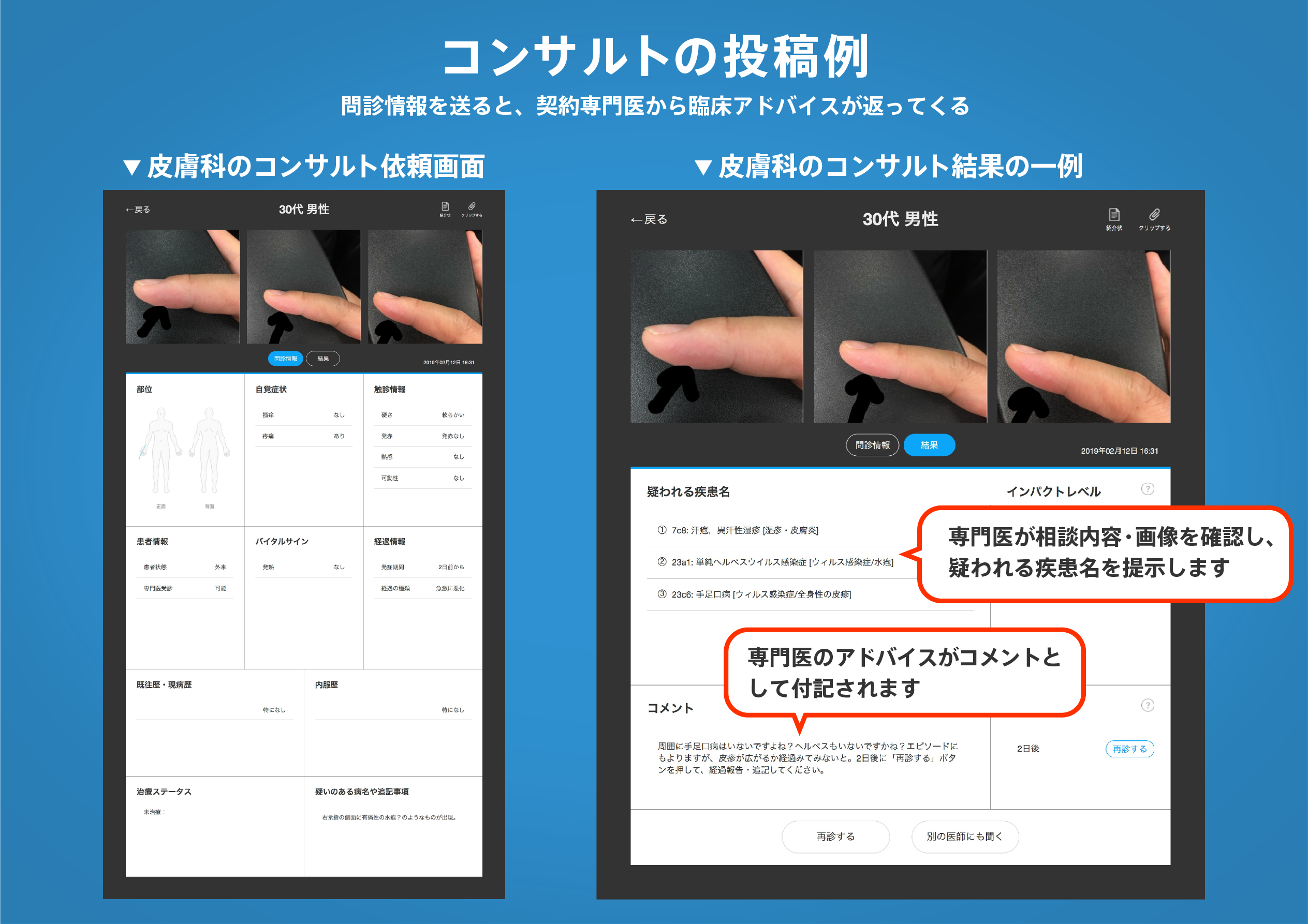
著名医師による解説が無料で読めます
すると翻訳の精度が向上します
このペーパーでは、iPhoneおよびiPadの光検出と範囲(LIDAR)を使用して、環境の小規模から中規模の3D表現を作成するためのオープンアクセス技術を活用する包括的なプロトコルを紹介します。このプロトコルは、iPhone Lidarの2つの機能に焦点を当てています。最初の機能は3Dモデリングです。iPhoneLidarは、詳細な屋内および屋外3Dモデルを迅速に生成し、オブジェクトサイズ、ボリューム、ジオメトリに関する洞察を提供します。2番目の機能は変化の検出です。Lidarセンサーによって作成された3Dモデルは、時間の経過に伴う変化を正確に測定するために使用できます。他の3D地形調査方法と比較して、この方法は迅速で、高解像度で、低コストで、使いやすいです。このプロトコルは、iPhone LIDARスキャンプラクティス、モデルのエクスポート、および変更の検出の概要を説明します。プロトコルを実行した後の予想される結果は、(i)中小サイズのオブジェクトまたは関心のある領域の詳細な3Dモデルであり、(ii)同じオブジェクトまたは異なる領域の2つのポイントクラウド間の変化を明らかにする距離点クラウドです。時代。プロトコル全体は、Lidarセンサーとコンピューターを備えたiPhoneを持っている人なら誰でも2時間以内に実行できます。このプロトコルは、科学者、学生、コミュニティのメンバーが、さまざまな質問や課題に対処するための安価で使いやすい方法で研究を行っているため、専門家とより広いコミュニティに利益をもたらします。
このペーパーでは、iPhoneおよびiPadの光検出と範囲(LIDAR)を使用して、環境の小規模から中規模の3D表現を作成するためのオープンアクセス技術を活用する包括的なプロトコルを紹介します。このプロトコルは、iPhone Lidarの2つの機能に焦点を当てています。最初の機能は3Dモデリングです。iPhoneLidarは、詳細な屋内および屋外3Dモデルを迅速に生成し、オブジェクトサイズ、ボリューム、ジオメトリに関する洞察を提供します。2番目の機能は変化の検出です。Lidarセンサーによって作成された3Dモデルは、時間の経過に伴う変化を正確に測定するために使用できます。他の3D地形調査方法と比較して、この方法は迅速で、高解像度で、低コストで、使いやすいです。このプロトコルは、iPhone LIDARスキャンプラクティス、モデルのエクスポート、および変更の検出の概要を説明します。プロトコルを実行した後の予想される結果は、(i)中小サイズのオブジェクトまたは関心のある領域の詳細な3Dモデルであり、(ii)同じオブジェクトまたは異なる領域の2つのポイントクラウド間の変化を明らかにする距離点クラウドです。時代。プロトコル全体は、Lidarセンサーとコンピューターを備えたiPhoneを持っている人なら誰でも2時間以内に実行できます。このプロトコルは、科学者、学生、コミュニティのメンバーが、さまざまな質問や課題に対処するための安価で使いやすい方法で研究を行っているため、専門家とより広いコミュニティに利益をもたらします。
This paper introduces a comprehensive protocol leveraging open-access techniques to create small- to medium-scale 3D representations of the environment by using iPhone and iPad light detection and ranging (LiDAR). The protocol focuses on two capabilities of the iPhone LiDAR. The first capability is 3D modeling: iPhone LiDAR rapidly generates detailed indoor and outdoor 3D models, providing insights into object size, volume and geometry. The second capability is change detection: the 3D models created by the LiDAR sensor can be used for precise measurement of changes over time. Compared to other 3D topographic surveying methods, this method is rapid, high resolution, low cost and easy to use. The protocol outlines iPhone LiDAR scanning practices, model export and change detection. The expected results after executing the protocol are (i) a detailed 3D model of a small- to medium-sized object or area of interest and (ii) a distance point cloud revealing change between two point clouds of the same object or area between different times. The entire protocol can be conducted within 2 h by anyone with an iPhone with the LiDAR sensor and a computer. This protocol empowers scientists, students and community members conducting research with a cheap, easy-to-use method for addressing a range of questions and challenges, thus benefiting experts and the broader community.
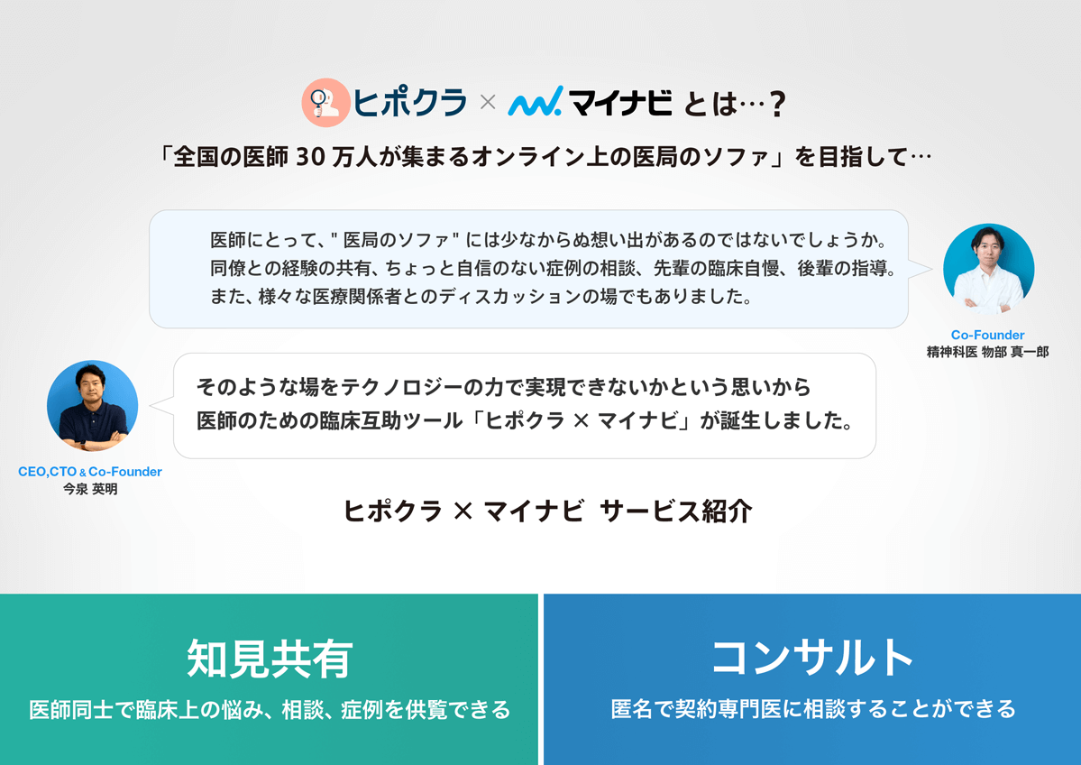
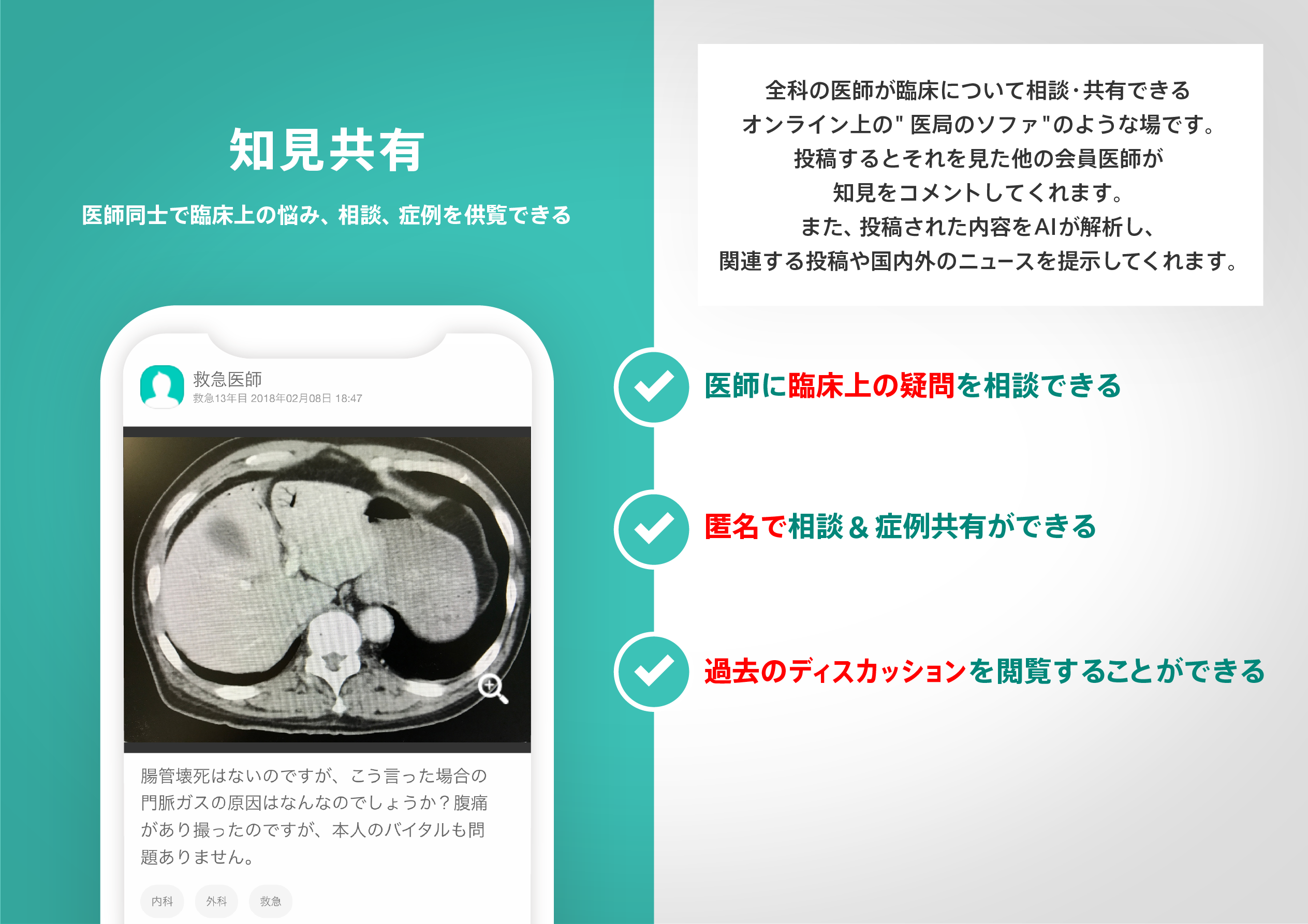
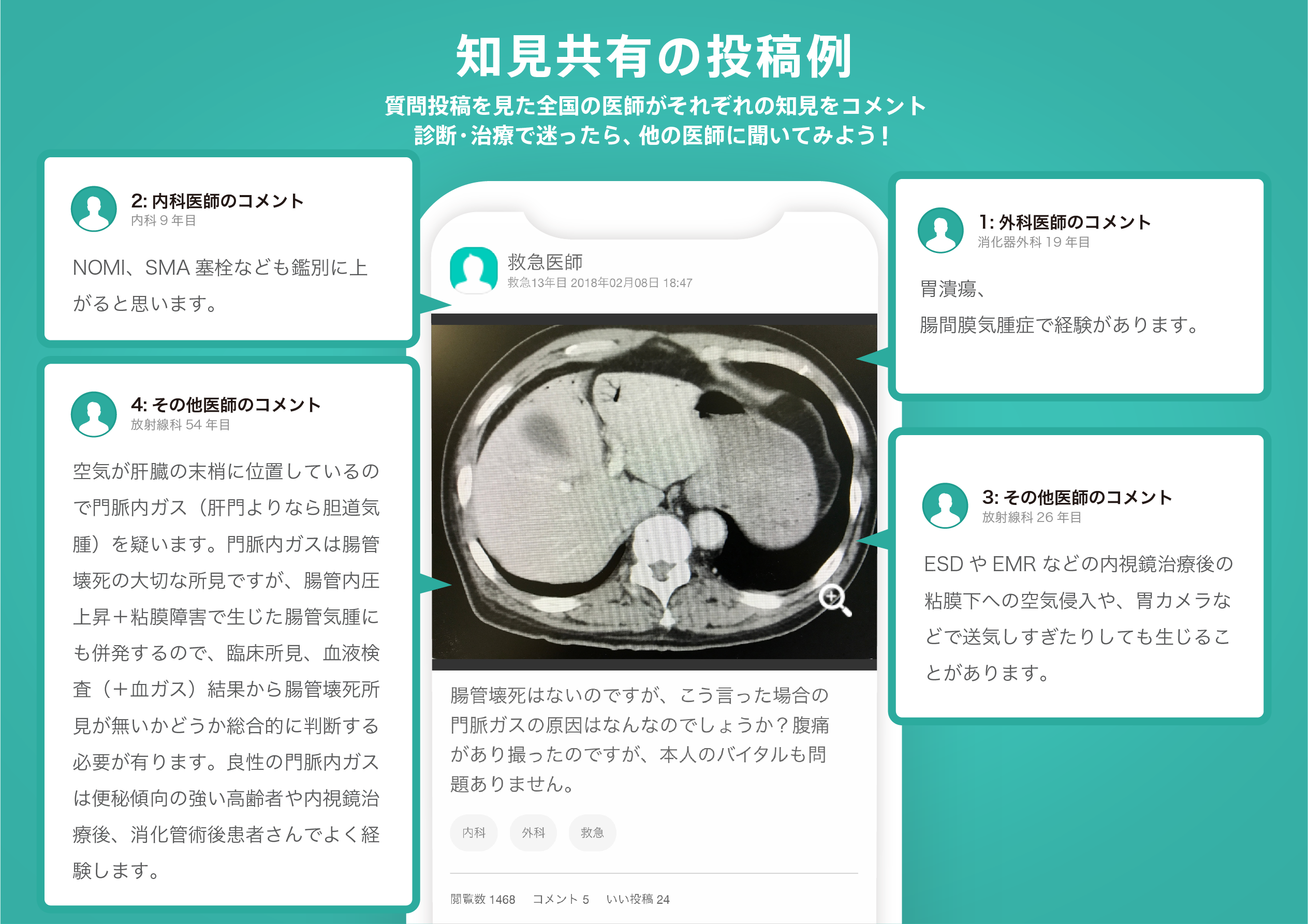
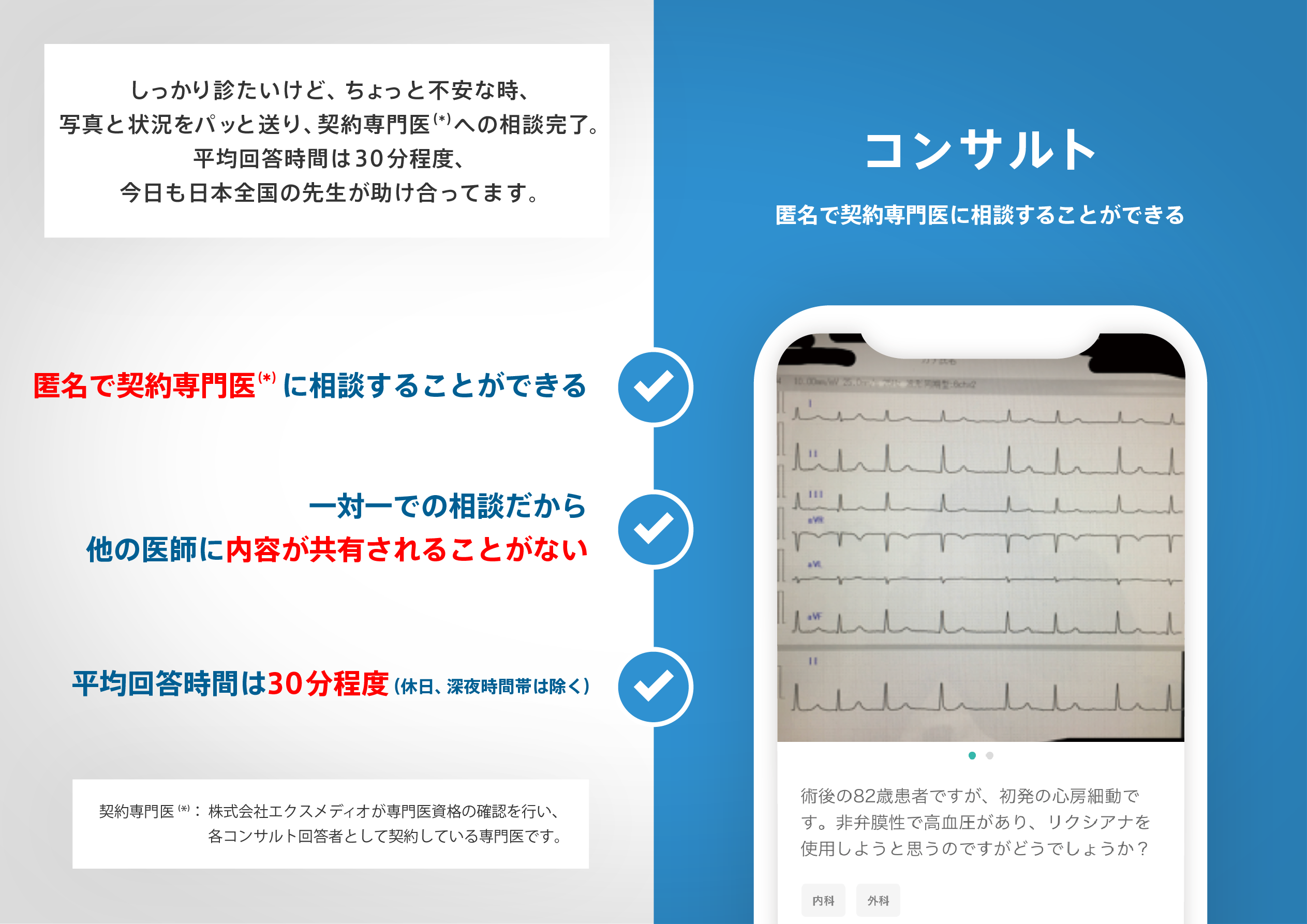
医師のための臨床サポートサービス
ヒポクラ x マイナビのご紹介

無料会員登録していただくと、さらに便利で効率的な検索が可能になります。